Boom
and bust
on Peery
Lake
Richard
T Kingsford
Principal Research Scientist
with the NSW National Parks and Wildlife Service
|
Boom
and bust Richard
T Kingsford |
 |
It was 1986 and we smelt the stench from the light plane about a kilometre from the lake. This was Peery Lake, now to be gazetted as our newest national park in the west. Thousands of dead fish littered the drying lake floor. Two to three years of flooding had allowed a massive fish population to build up in the lake but the natural drying processes had taken their toll, particularly on the introduced carp. Towards the deeper part, Australian pelicans sat unmoved by our noisy aeroplane, presumably gorged on the fish. Within months the lake was a dustbowl, in stark contrast to today’s lake. |
Record rains of more than 300 mm fell overnight in the middle of February this year, exceeding average rainfall for a year. Peery Lake, already full from previous floods of the Paroo River, will overflow into downstream lakes and floodplains until the water eventually reaches the Darling River. Since 1986, I have seen Peery Lake during dry and wet periods, the boom and bust times, driven by the unpredictable flows of the Paroo River. It is a magnificent natural ecosystem wrapped in rich ecological and cultural layers.
Peery Lake is nearly 30 km long and together with the other Paroo overflow lakes (Mullawoolka Basin, Yantabangee Lake, Poloko Lake, Gilpoko Lake and Tongo Lake) extend as great gashes running north-south in the landscape. Peery Station, the new reserve to be known as Peery National Park, is about 30 km east of the town of White Cliffs and covers 42,480 ha. It includes the northern third of Peery Lake and the northern part of the next lake to the east – Poloko Lake. The park also includes the sandstone and quartzite ridges and their stony hills, which tower 120 m over the western shoreline of the lake. Here, there are common woodland plants such as mulga, belah, leopardwood and emu bush.
Temporary creeks (Camp, Goanna Gully, Prickly Wattle, Rutherford, Box, and Howells) flow into the lake from the north-west and actually filled the lake in the early 1980s following heavy thunderstorms. They are fringed by plants reliant on flooding: river red gum, yapunyah, black box, prickly wattle, river cooba, lignum and canegrass.
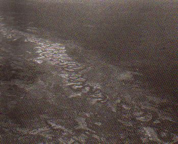
Typical floodplain detail - the Darling
River/Barwon
Photo : DEBORAH
STEVENSON
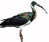
About 256 plant species are recorded for the na- tional park. Peery Lake with water is a spectacular site, particularly when thousands of waterbirds pepper its brown surface. Pink-eared ducks, usually in small flocks near the edge, busily sieve the enormously rich invertebrate mix. Hardhead dive for large invertebrate prey in the middle of the lake. Flocks of hundreds or more of Australian pelicans herd fish in the shallows or form frenetic feeding flocks with cormorants in the middle of the lake; all this makes the surface of the lake boil with birds. Native fish populations on the Paroo River and its lakes are amongst the healthiest in the Murray-Darling Basin rivers, despite the presence of carp. When small islands form towards the southern end of the lake, pelicans sometimes breed. One of the rarer species of duck in Australia, the freckled duck, has been seen on the lake in numbers of more than 1,000 birds.
|
Spoonbills, brolgas, ibis,
red-necked avocets, black swans, Eurasian coot, blue-billed duck and the
list goes on, have all been at some time feeding or breeding on or near
the lake.
Total numbers of waterbirds on the lake are equally spectacular. Our aerial surveys estimated 36,000 during March 1993 and we know that these surveys can underestimate by up to 50%. Once full, Peery Lake holds water for two or three years before drying. The windswept dry lake bed is an inhospitable place, but some water persists near its western edge. |
 |
Here also lie the largest active mound springs in NSW. Most of us learn about the Great Artesian Basin in primary school and how the sinking of bores allowed pastoralism to be established across large areas of arid Australia. In some places, such as Peery Lake’s mounds springs, this water naturally bubbles to the surface. Thousands of years of sedimentation have formed mounds of soil two metres high and two metres in diameter on top of these springs where rare plants, salt pipewort Eriocaulon carsonii and club rush Schoenoplectus pungens, depend on the flowing water from the springs. This perennial source of water in an arid landscape was essential for the original human inhabitants.
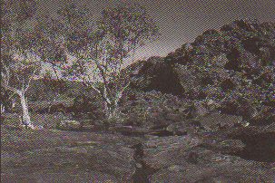
Rock formations
in Peery NP
Photo : KEVIN SHANAHAN
Peery Lake is a place of major cultural significance for Aboriginal people of the Barkindji. Stories of the dreaming time have woven in the landscape of the lake, springs, lunettes and the surrounding country. The lake is connected to two main Aboriginal Dreaming tracts: the two Rainbow Serpents and Guliberri, a major creation ancestor for the region. Rock engravings, artefacts, painted art sites, stone arrangements and camp sites bear testament to a rich cultural history. There are large flat slabs for crushing grass seeds, and mortars and pestles for grinding harder seeds. Flaked stone tools are numerous and there is evidence for specialised workshops where backed blades (probably stone inserts in wooden spear heads) were manufactured. Large bone middens are found in the lunettes, which border the eastern edge of the Lake. Here the burnt bones of large mammals and fish date back 8,000 to 9,000 years and are amongst the best archaeological digs of fauna in NSW.
|
Rich food sources – birds, fish, mussels in the river and the lakes of the Paroo – would have meant that this area was probably permanently inhabited. European colonisation brought foreign disease and dislocation of many communities from their land. Many Aboriginal people living around Peery Lake died, possibly from smallpox during the early years of colonisation. Aboriginal people of the Paroo now live in Wilcannia but still have a deep connection with the area. |
Now that it is to be a national park Peery Station will remain protected for future generations. True or false? Most of us might settle down in our urban chairs and say, "a job well done", and answer in the affirmative. We would be wrong. Our reserve network, national parks and nature reserves, is primarily for the reservation of land. Unfortunately, national park status does nothing to protect the vital natural resource for Peery Lake – water.
The water for Peery Lake comes primarily from the Paroo River whose source is more than 600 km to the north in Queensland. Along the way, the Paroo River fills a floodplain of more than 780,000 ha which, with the Warrego River floodplain of a similar size, remain the most extensive floodplains of any catchment in the Murray-Darling Basin. Once this vast complex of wetlands is filled, water usually then fills the Paroo River overflow lakes of which Peery Lake is the largest. Our insatiable desire to divert water for irrigated agriculture – this time in Queensland – hangs like the Sword of Damocles over the entire Paroo River, including Peery Lake.
| Recognition of the Paroo River’s status as the last free-flowing river in the Murray-Darling Basin and its incredible biological diversity holds some hope that we will not follow history’s well-trodden path of declaring another river ripe for water-resource development without acknowledging the inevitable ecological consequences. | |
Richard T Kingsford is Principal Research Scientist with the NSW National Parks and Wildlife Service.
|
Richard
Kingsford will be giving a talk in the annual NPA lecture series, |
|
|
National
Parks Association - Home Page |
|