Back to Contents
Back to Contents
|
Cover Story |
The Lansdowne Volcanics
New
reserves on the Comboyne & Lansdowne escarpments
Terry Evans
NPA member
Environmental Manager
Back to Contents |
The Lansdowne Volcanics New
reserves on the Comboyne & Lansdowne escarpments |
|
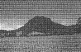
Prior to the recent Lower North East Regional Forest Agreement, the Manning Region – centred on Taree on the Mid North Coast of NSW – was particularly poorly endowed with nature conservation reserves, existing national parks and nature reserves barely covering 2% of the land area. With the enactment of the Forestry and National Park Estate Act 1998, a number of new national parks and nature reserves were established in the region, bringing the proportion in reserves to a more respectable10%. Among the new additions are four natural gems that dominate the spectacular escarpment fringing the Comboyne Plateau and the nearby Lansdowne Valley. The four are Coorabakh National Park, Killabakh Nature Reserve, Coxcomb NR and Goonook NR. These reserves have all been long-standing NPA proposals. |
| The four reserves in part
protect a landscape that is visually stimulating and has regional scenic
significance. The landscape mainly consists of a steeply dissected
sedimentary escarpment interspersed with numerous volcanic plugs and
associated trachyte flows. The upper escarpment is fringed by a fertile
basalt plateau, while lower down plunging ridgelines and low rounded
hills dissipate into a subdued landscape of alluvial terraces (Pain
& Ollier, 1986).
The Lansdowne Volcanics are associated with the Comboyne Shield Volcano, a past catastrophic event that would appear to be a consequence of the passage of the Australian continent over a "hot spot" within the earth’s mantle. The residual volcanic structures are of considerable geological significance because they provide an exceptional insight into the evolution of the Great Escarpment in NSW. The Comboyne Plateau and the adjacent Bulga Plateau are now outlying residuals of the Great Escarpment which, as a result of scarp retreat, has migrated further to the west. According to Pain and Ollier, "the Comboyne basalts and related volcanic plugs enable a chronology to be derived, and in the immediate area of the plateaus, scarp retreat has brought their escarpments to their present position within the past sixteen million years". This age has been confirmed by dating of Tertiary volcanic rocks from the trachyte plugs and flows on and adjacent to the Comboyne Plateau. |
|
The dramatic landscape – when combined with a high and relatively dependable rainfall, a range of soil types, variable aspect and altitude – provides diverse habitat for many rare and often threatened native plants and animals.
As a result of numerous surveys and assessments, at least twelve mammals, four birds, one reptile and three amphibians listed in the schedules of the Threatened Species Conservation Act are known to occur within the four reserves. At least three additional threatened species – two mammals, one bird and one amphibian – are likely to be present.
Coorabakh National Park (1,840 hectares)
This small national park was previously part of Lansdowne State Forest. It is dominated by three prominent volcanic intrusions known locally as the Nellies. Big Nellie, which is marginally the highest plug, rises to 560 metres above sea level, Little Nellie has an elevation of 555 m, and Flat Nellie 485 m.
The Nellies are pyroxene-rich trachyte plugs that are the remains of a Tertiary volcanic event where Triassic sediments including conglomerates and sandstones were subject to intrusion by a hot, viscous, silica-rich lava. Because of these different parent materials, soils resulting from weathering vary considerably in nutrient status, although they are generally sandy and free draining. The resulting vegetation is relatively complex with twelve known vegetation communities. These range from rainforest through to tall open forest, which occurs extensively throughout the park, but also include scattered shrubs and shrubby thickets on the summits of the volcanic plugs. There are also upland heaths on dry sandy regoliths, particularly around Flat Nellie.
At the head of Starrs Creek there is a significant stand of what can best be described as transition rainforest. This patch is unusual in that it contains distinct elements of both warm temperate and sub-tropical rainforest. Coachwood (Ceratopetalum apetalum) dominates the creek terrace, while on the more elevated colluvial slopes sub-tropical elements, including black booyong (Heritiera actinophyllum) and yellow carabeen (Sloanea woollsii), dominate the canopy. The understorey and middle storey, however, contain a distinctive warm temperate element.
The unique quality of the park is exemplified by the significant number of plant species that are present, many of which are considered to be rare and/or threatened; or are at their geographic limits of distribution; or are isolated relic outliers; or alternatively are endemic to the general location of the park. Notable species include two rare plants that have only recently been scientifically described, Hakea archaeoides and Dracophyllum macranthum.
Similarly the park has a rich fauna, important examples of which include a number of threatened species, such as the spotted-tailed quoll (Dasyurus maculatus) and powerful owl (Ninox strenua).
Killabakh Nature Reserve (2,644 ha)
Killabakh NR is a fragmented reserve consisting of four separate sections. The major part of the reserve was previously included in Marsh State Forest. The remainder, which includes Killabakh Mountain and a small outlier of rainforest straddling the Comboyne Road, were previously Crown reserves. Killabakh Mountain is the most prominent feature in the nature reserve and it effectively delimits the southern edge of the Comboyne Plateau. This trachyte residual rises to an elevation of 865 m above sea level and loftily dominates the southern edge of the plateau and its escarpment. In the north, Comboyne basalts extend away from the main plateau along a narrow peninsula-like projection to merge with the more resistant trachyte on Killabakh Mountain.
The nature reserve sits virtually astride the escarpment, where scarp retreat has exposed a stratified sequence of parent materials. This has resulted in a varied but predictable soil landscape. Thin sandy skeletal soils derived from silica-rich trachyte tend to form on and adjacent to Killabakh Mountain, while moderately fertile red kraznozem soils derived from Tertiary basalt, iron-rich sandstones and mudstones extend north to the main plateau.
The remainder of the escarpment is dominated by much older sandstones and mudstones of the Permian period, which substantially predate the volcanic activity on the plateau. Weathering of the Permian sediments has resulted in the formation of less fertile and relatively more erosion-prone, yellow podzolic soils.
Soil type and aspect tend to be the major factors that determine vegetation communities as rainfall is uniformly high and generally reliable, and fire is relatively infrequent. Open forest communities occupy much of the nature reserve; however, a significant amount of rainforest is also present where conditions are suitable. Sydney blue gum (E. saligna)/tallowwood (E. microcorys) communities cover about 45% of the reserve. These communities generally occupy moist protected sites on the deeper yellow podzolic soils.
The vegetation on the rocky summit of Killabakh Mountain and the adjacent cone-shaped "pinnacle", similar to the other volcanic outcrops, is a mix of stunted open forest, woodland and shrubland. On the summit of the pinnacle where soils are very thin, Blue Mountain Ash (E. oreades) occurs in an adult form as a whipstick mallee, while on slopes where soils are deeper it occurs as a tree of 25 m in height.
The real value of the reserve lies with its amazingly rich fauna. Eleven threatened species are present within the reserve. A further eleven threatened species could also potentially occur here. Species of particular interest include the wompoo fruit-dove (Ptilinopus magnificus) and the fascinating Stephen’s banded snake (Hoplocephalus stephensii). This unusual and otherwise relatively rare semi-arboreal elapid occurs fairly commonly in the nature reserve.
Similarly the wompoo fruit-dove, a sighting of which a few years ago would have been considered unusual, but is now almost a common event. This increased presence would appear to be a result of improved rainforest conservation, and possibly the demise of subsistence farming with a consequent removal of "wompoo pigeon" from the local menu.
|
Coxcomb Nature Reserve (73 ha) This small nature reserve protects the trachyte plug known as Mount Coxcomb. The plug, which is typically cone-shaped, rises to a height of 480 m and has sheer rocky cliffs on three sides. It is a very distinctive part of the landscape of the Upper Lansdowne Valley, and is flanked by a suite of similar volcanic intrusions including Mount Goonook, Mt Bally and Mt Gibraltar, none of which are within reserves. |
|
Open forest covers the mid and lower slopes, while the remainder of the rocky surface is either bare or interspersed with scattered shrubs or shrubby thickets. On the summit there is a gnarled shrubby woodland community. No detailed assessment of fauna has so far taken place, however, the narrow rock shelves that overhang the cliffs provide exceptional nesting sites for the peregrine falcon (Falco perigrinus).
Goonook Nature Reserve (930 ha)
Goonook NR was originally part of Yarratt State Forest. It takes its name from the adjacent volcanic plug known as Mount Goonook. The plug dominates the ridge country north of the reserve. This ridge country forms a naturally vegetated corridor linking the escarpment forest with the lowland forests of the Dawson River catchment. Mount Goonook stands just outside the nature reserve and is privately owned.
The steep and rugged nature of Mount Goonook contrasts starkly with the gently incised ridge country. Much of the reserve lies upon a nominal thrust fault which basically coincides with a low longitudinal ridgeline. The geology is essentially sedimentary with strata of different ages merging on the fault line. Permian sediments (250 million years old) rise over older Carboniferous sediments (330 million years old). The Permian sediments consist mainly of mudstones and pebbly mudstones while the Carboniferous sediments consist mainly of siltstones and shales. The mudstones have weathered to form brown podzolic soils of low to medium fertility, while the siltstones and shales have weathered to form lateritic podzolic soils of low nutrient status.
Characteristically this geology has resulted in the dominance of open forest communities, with moister types only occurring in the deeper gullies where aspect generally influences the micro-climate. The main vegetation consists of the wet and dry phases of the small-fruited grey gum (E. propinqua)/grey ironbark (E. placita)/white mahogany type.
The grey gum forests, particularly where tallowwood is a major associate, provide core habitat for a small koala population. In fact, the nature reserve is probably the only secure habitat for the koala within the Dawson River catchment. This is particularly significant as this catchment now carries a major part of the koala population still remaining within the Lower Manning Valley.
Future management
The four reserves are small but important stepping stones in an extensive wildlife corridor which links the Great Escarpment with the coast. Though integral to the long-term conservation of this regional corridor, the reserves in themselves are not sufficient to adequately conserve it. Conversely, if the corridor is not adequately conserved these reserves potentially could become isolated islands of habitat, resulting in a long-term loss of biodiversity.
Fortunately, this corridor has long been recognised by the local community for its nature conservation values. As a consequence, in 1995 much of the land within the corridor was zoned either 7(a) Environmental Protection (Habitat) or 7(d) Environmental Protection (Scenic) (Evans & Deer, 1996). Although such zonings do not prevent all development, they do act as an effective planning filter to prevent the more undesirable and damaging types of development.
In the future there is the possibility of adding new lands to the NPWS estate. Another mechanism is the establishment of voluntary conservation agreements. Two such agreements have already been entered into over land within the corridor, and additional agreements are likely. There are a number of wildlife refuges and it is understood there is a proposal for a property agreement, under the Native Vegetation Conservation Act, under consideration.
This cooperative mix of government and community conservation initiatives is promising, and is indicative of a model for managing a landscape under different tenures to achieve desired nature conservation objectives.
The four reserves are managed by the Mid North Coast Region of the NPWS from the Manning Area Office, based at Taree.
Terry Evans
NPA member
Environmental manager
References
Pain C.F. and Ollier C.D. (1986) "The Comboyne & Bulga Plateaus and the Evolution of the Great Escarpment N.S.W". Pro. Royal Soc. of N.S.W., Vol 119 (pp123-130)
Evans T. & Deere W. (eds) (1996) State of The Environment Report 1995, Greater Taree City Council.
|
|
National
Parks Association - Home Page |
|